 by Bryka257
The Story of Mwekera Forest Reserve from a spatial-temporal Perspective
MAY 11, 2024

The Story of Mwekera Forest Reserve from a spatial-temporal Perspective
By Jeffery Mwila
Wildlife Ecologist (Avifauna Expert)

Let us journey through time and space within the Mwekera Forest Reserve, an extraordinary ecosystem in Zambia’s heart. Through a spatial-temporal lens, we can witness the ebb and flow of life within its boundaries – from the birth of a tiny seedling to the majestic soaring of an eagle high above the canopy.
However, amidst this natural splendour, human actions have cast a shadow. The echoes of illegal logging, encroachment, and unsustainable practices resonate throughout the forest reserve, threatening the very fabric of Mwekera’s existence. These anthropogenic intrusions have caused immense damage to the ecosystem, leading to soil erosion, loss of biodiversity, and altered hydrological cycles. The once-vibrant forest reserve now stands at a crossroads, yearning for reprieve from the relentless march of progress.
It is more important than ever to recognise the significance of Mwekera Forest Reserve and take action to protect it for future generations. We must work together to promote sustainable practices that allow the forest reserve to thrive and co-exist with human activities. The future of this unique ecosystem is in our hands, and we must act now to ensure that it continues to flourish in all its natural beauty.

1990 – LULC |

2000 – LULC |
|
2010 – LULC |

2020 – LULC |

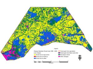
Change Detection (Forest loss) 1990 – 2020.
Interact with the maps – click here!
Time to act now!
# Spread the word, lend your voice, and support initiatives safeguarding Protected areas in Zambia and across the Globe.
Disclaimer: Land Use Land Cover Maps
Disclaimer: Land Use Land Cover
The Land Use Land Cover (LULC) maps are an informational and illustrative tool, offering insights into land use and cover distribution within a specific geographic area. While efforts have been made to ensure its accuracy and reliability, it may not reflect real-time or ground-truth conditions. Users should exercise discretion and consult authoritative sources for precise land use information. Interpretation of the LULC maps may vary based on the methodology, classification, LULC classes, Spatial and Temporal resolution and data sources used in making the maps. The LULC maps may not capture all nuances or changes in land use and land cover over time. The maps are intended to provide an overview and may not reflect localised variations or recent developments. While valuable for research and planning, it should not be the sole basis for critical decisions without validation from on-the-ground surveys or expert consultation. By accessing and using the LULC maps, users acknowledge and accept its limitations and disclaimers.
For inquiries or further information, don’t hesitate to contact us